- Tour Packages
- Discover Macau
- Tourist Attractions
- Heritage Sites
- A-Ma Temple
- Macau Wine Museum
- Grand Prix Museum
- Moorish Barracks
- Lilau Square
- Mandarin's House
- St. Augustine's Square
- Dom Pedro V Theatre
- Sir Robert Ho Tung Library
- Leal Senado' Building
- Senado Square
- Sam Kai Vui Kun (Kuan Tai Temple)
- Lou Kau Mansion
- Na Tcha Temple
- Section of the Old City Walls
- Mount Fortress
- Casa Garden
- Churches in Macau
- Ruins of St. Paul's
- Hotels
Geography
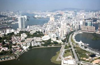
Macau is situated 60 kilometers (37 mi) southwest of Hong Kong and 145 kilometers (90 mi) from Guangzhou of Mainland China. It also has 41 kilometers (25 mi) of coastline, yet only 310 meters (1,000 ft) of land border with Guangdong of Mainland China. It consists of the Macau Peninsula itself and the islands of Taipa and Coloane, which are now connected by landfill forming Cotai. The peninsula is formed by the Zhu Jiang (Pearl River) estuary on the east and the Xi Jiang (West River) on the west. It borders the Zhuhai Special Economic Zone in mainland China. The main border crossing between Macau and China is known as the Portas do Cerco (Barrier Gate) on the Macau side, and theGongbei Port of Entry on the Zhuhai side.
Macau Peninsula was originally an island, but a connecting sandbar gradually turned into a narrow isthmus, thus changing Macau into a peninsula. Land reclamation in the 17th century transformed Macau into a peninsula with generally flat terrain, though numerous steep hills still mark the original land mass. Alto de Coloane is the highest point in Macau, with an altitude of 170.6 meters (559.7 ft). With a dense urban environment, Macau has no arable land, pastures, forest, or woodland.